Celtic Europe
25 Jun 2024 17:52
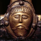
The silver spear of Olyndicus; by 19th-20th century anonymous artist “Navarrete”. 🇪🇸 The scene depicts the outbreak of the Numantine War (143-133 B.C.), the most famous conflict between the Celtiberian people and the Roman Republic.
The Romans had been fighting (and losing) a war against the Lusitanian hero Viriathus since 148 B.C. (the so-called “War of Fire”). One of Viriathus’ master plays during the conflict was an expedition to Celtiberian lands, where he instigated his allies among them to revolt. The Celtiberian Arevaci tribe was keen to help Viriathus and throw off the Roman yoke; it didn’t take much to persuade them to revolt.
According to the Roman historian Florus, they were led by a chieftain and priest by the name of Olyndicus (some copies of Florus’ text render the name Olonicus, others Salendicus). Olyndicus acted as a kind of prophet to galvanize his people. The narrative he used is unknown, but it included brandishing a silver spear that he claimed had been sent from heaven by the gods. At the outset of the war, the Romans nearly suffered disaster, but got lucky: Rome had dispatched consul Quintus Caecilius Metellus “Macedonicus” with a huge army to crush the revolt. Olyndicus led a surprise night attack on the Roman camp that came close to killing the consul himself. But the Celtiberian leader was killed in the battle by a lucky throw of a Roman javelin. Demoralized by this sudden reverse, the Celtiberians retreated and most of the tribes subsequently negotiated a surrender. But several towns, most notably Numantia, obstinately held out. For the next nine years, the Romans sent army after army to crush them, but suffered continual humiliating defeats. Only a protracted siege with a massive army led by consul P. Cornelius Scipio Aemilianus was able to finally break the Numantines, most of whom committed suicide rather than surrender.
Celtic Europe - channel link (please share!): /channel/CelticEurope
Читать полностью…
Celtic Europe
08 Jun 2024 20:43
A small beach on the Sleat Peninsula (Gaelic: Sleibhte; “Mountains”) of the Isle of Skye; Scotland. 🏴
Celtic Europe - channel link (please share!): /channel/CelticEurope
Читать полностью…
Celtic Europe
03 Jun 2024 18:46
The Norrie’s Law Hoard, a 5th-6th century AD stash of Pictish silver, found in a small mound near the village of Upper Largo, in Fife, Scotland. 🏴
The hoard originally contained 12.5 kg of late Roman and Pictish silver, including two Roman coins. After discovery, large amounts of it were pilfered, melted down and sold, so that currently there is less than 1kg remaining. Given that the hoard belongs to a time period of extreme turmoil, and that it contains late Roman items and hack silver, it’s likely that the silver was obtained as plunder taken in raids on sub-Roman Britain, and/or as tribute paid to avert the same. Obviously, some of the silver was then melted down by a Pictish craftsman and worked into pieces of fine jewelry.
Celtic Europe - channel link (please share!): /channel/CelticEurope
Читать полностью…
Celtic Europe
02 Jun 2024 17:17
Bronze fixture for a chariot yoke, decorated with stylized bull and bird heads. Found among the ruins of the Gallic town of Manching, in Bavaria, Germany; 2nd century B.C. 🇩🇪
Celtic Europe - channel link (please share!): /channel/CelticEurope
Читать полностью…
Celtic Europe
01 Jun 2024 17:08
A map of medieval Ireland (10th century), with the Gaelic Kingdom of Arigíalla highlighted. 🇮🇪
Initially much larger, much of Airgíalla’s territory was taken over by the Northern Uí Néill, of whom, ironically, the Airgíalla were vassals and allies. According to legend, the kingdom was founded in AD 331 by brothers known as the “Three Collas”. That year, they supposedly invaded Ulster with an army from Connacht, winning the Battle of Achadh Leithdeircc and killing king Fergus Foga. They then burnt Emain Macha and carved out a new kingdom for themselves. Years before, they’d killed their uncle, High King Fíacha Sroiptine in battle and taken his throne. But Fíacha’s son Muiredach Tíreach overthrew them and forced them to flee to Britain. They returned with 300 warriors, seeking to provoke Muiredach to battle, but Muiredach took them into his service and persuaded them to invade Ulster instead.
Modern genetic studies suggest the legend of the Three Collas might be pure fiction. DNA analysis of men tracing their descent from the clans of Airgíalla (supposedly descendants of the Three Collas) has been yielding surprising results: Most of the Y-chromosome lineages trace back to eastern England, meaning the Airgíalla are primarily descended (in the male line) from Celtic Britons, probably from around Colchester (i.e. the Celtic Trinovantes tribe). Interestingly, the same Y-chromosome haplogroup is commonly found in men of the Scottish Clan MacDonald. This appears to confirm ancient lore and genealogies tracing the MacDonalds back to Airgíalla ancestors. A Scottish text, the Senchus Fer n-Alban, mentions Airgíalla as vassals of the Cenél Loairn tribe of the Kingdom of Dál Riata. It would thus appear that some Irish Airgíalla were among the colonists who settled Scotland when Dál Riata was founded (6th century AD). Their territory, and Clan MacDonald’s ultimate place of origin, seems to have been the southern Outer Hebrides islands.
Celtic Europe - channel link (please share!): /channel/CelticEurope
Читать полностью…
Celtic Europe
27 May 2024 18:43
Sheep and heather in the Wicklow Mountains of Ireland. 🇮🇪
Celtic Europe - channel link (please share!): /channel/CelticEurope
Читать полностью…
Celtic Europe
24 May 2024 17:09
The hill of Allt Cunedda, near Kidwelly; Carmarthenshire, Wales. 🏴
Local tradition has it that the founder and first king of Gwynedd, Cunedda Wledig, son of Edern, was killed here. Cunedda was a chieftain from the northern region of Manaw Gododdin, located around present day Falkirk in what’s now Scotland. In the 5th century AD, he was invited by the rulers of southern Britain —possibly even Vortigern himself— to come to Wales and re-conquer large parts of it from Irish invaders who’d taken over and colonized the area. After many years of fighting, Cunedda and his people were successful in either killing or driving out most of the Irish from northern and western Wales. They carved out two kingdoms from the territories they had acquired: Gwynedd and Ceredigion. The old folk tale recorded around Kidwelly held that later on, Cunedda came to the area with his army, seeking to make additional conquests in south Wales (the area was part of the Kingdom of Dyfed at that time). At the hill that bears his name, he was met by a large band of locals (presumably including Irish colonists), who fought a battle against him in which he was finally defeated and killed. Cunedda was said to have been buried nearby; his sons Einion Yrth and Ceredig followed him as kings of Gwynedd and Ceredigion respectively.
Celtic Europe - channel link (please share!): /channel/CelticEurope
Читать полностью…
Celtic Europe
21 May 2024 17:14
Great Sugar Loaf Mountain (Irish: Ó Cualann; “Lump of Cualu”), with heather prairie blooming in the foreground and the remainder of the Wicklow Mountains in the background; county Wicklow, Ireland. 🇮🇪
The name of this mountain reflects the original and more ancient name of the region, for Cualu was the name of a territory that encompassed almost the whole of present county Wicklow and parts of county Dublin, from Arklow to the river Liffey. According to the Irish place-name index, www.logainm.ie, the Wicklow Mountains were also formerly known as Sliabh Ruadh, meaning “Red Mountain”. The current Irish name is Sléibhte Chill Mhantáin, meaning “Mountains of the Church of St. Mantan”, and is more modern.
Celtic Europe - channel link (please share!): /channel/CelticEurope
Читать полностью…
Celtic Europe
20 May 2024 15:52
Pictish symbol stone depicting a battle against Anglo-Saxon invaders, from the churchyard of Aberlemno, in Angus; Scotland. 🏴⚔️🏴
The stone is thought to depict the Battle of Dún Nechtáin, fought on May 20 of the year AD 685, between the Anglo-Saxon Kingdom of Northumbria and the Pictish Kingdom of Foirtriu. Northumbria had been extending its power northward into northern Scotland, trying to subdue and annex the whole of northern Britain. Strong resistance seems to have coalesced around the Pictish king of Foirtriu, Bridei III, son of Beli. The Anglian king Ecgfrith, son of Oswiu, led an immense army into Scotland in hopes of finally crushing that resistance. According to the English historian Bede, the Picts lured the Anglo-Saxon army deep into Scotland to a pre-selected battlefield, where it was defeated and cut to pieces in one of the bloodiest battles of that entire period. Ecgfrith himself was killed —the stone seems to show him in the lower right, being eaten by a raven— along with his entire army. The Picts not only shook off Northumbrian domination, they permanently broke the kingdom’s power; Northumbria would never again achieve hegemony in Britain.
Celtic Europe - channel link (please share!): /channel/CelticEurope
Читать полностью…
Celtic Europe
18 May 2024 16:20
Stone effigy representing a king, found among the ruins of Deganwy Castle, in Conwy, Wales; early 13th century. 🏴 The sculpture is believed to be a portrait of king Llywelyn ab Iorweth, also known as “Llywelyn the Great”, who ruled the Kingdom of Gwynedd from 1195 to 1240, being regarded as one of Wales’ most successful monarchs.
Celtic Europe - channel link (please share!): /channel/CelticEurope
Читать полностью…
Celtic Europe
14 May 2024 17:57
Fragment of a Pictish carved stone found at Forteviot, in Strathearn, Scotland; 9th century AD. 🏴 The bizarre imagery features a bull biting a serpent. Forteviot was the first royal seat or inaugural site of the kings of Alba (i.e. Scotland), and the stone is thought to date to the early days of the kingdom when it was first founded.
Celtic Europe - channel link (please share!): /channel/CelticEurope
Читать полностью…
Celtic Europe
13 May 2024 18:42
View of Benbulben mountain from Rosses Point, in county Sligo, Ireland.
Rosses Point was the site of a medieval battle between the Irish Kingdom of Tír Chonaill and the Kingdom of England. 🇮🇪⚔️🏴 The Battle of Creadran Cille was fought in the year 1257, resulting in victory for king Gofraidh Ua Domhnaill (Anglicized: Geoffrey/Godfrey O’Donnell) of Tír Chonaill. The forces of the English Lordship of Ireland were led by Maurice FitzGerald, 2nd Lord of Offaly. FitzGerald and O’Donnell met in single combat during the battle, inflicting severe wounds upon each other, from which they both later died. FitzGerald’s army suffered severe losses and was ultimately put to flight. The Irish followed up the battle by sacking and burning the town of Sligo. The battle was a revanche for Tír Chonaill, which had lost the Battle of Ballyshannon ten years earlier against the same FitzGerald, who held the title of Chief Justiciar of Ireland at that time (i.e. governor or viceroy). Gofraidh’s predecessor as king of Tír Chonaill, Máel Sechnaill Ua Domhnaill, had lost his life in that battle.
Celtic Europe - channel link (please share!): /channel/CelticEurope
Читать полностью…
Celtic Europe
08 May 2024 16:51
The city of Karadeniz Eregli (formerly Heraclea Pontica), on the Black Sea coast of Turkey; fourth photo shows the ruins of the ancient town. 🇹🇷
Heraclea Pontica was founded as a trading colony by the Greek city-state of Megara, before eventually becoming independent. During antiquity, Heraclea had several notable conflicts with the Celts who’d settled in Anatolia. In his History of Heraclea, the Greek historian Memnon recorded how the Galatians ravaged the territory of Heraclea in the year 254 B.C; this was punishment for having opposed them when they placed Ziaelas on the throne of Bithynia. Hostilities broke out again in 250 B.C; when king Ariobarzanes of Pontus died while caught up in a dispute with the Galatians. When his young son, Mithridates II succeded him, the Celts invaded Pontus and devastated it. But Pontus held out thanks to the inhabitants of Heraclea Pontica, who’s fleet supplied the city of Amisos, and thereby the whole of Pontus, with grain. For this, the Celts again exacted a harsh revenge, ravaging Heraclea’s territory until the city sued for peace. Peace was granted upon the payment of 5,000 gold coins to the Galatian army as a whole, plus an additional 200 gold coins to each of the chieftains.
Heraclea would again be attacked by the Celts in the decade of the 190s B.C; and subjected to a long siege. However, on this occasion, they seem to have been led by an incompetent general, who left camp with most of his army in order to resupply it by plundering the surrounding countryside. The Heracleans took advantage to make a sally and score an easy victory against a meagre force left behind to guard the camp, causing the siege to be lifted. This was the last encounter between the Galatians and the Heracleans. In subsequent years, both would suffer severely at the hands of Pontus, as the latter rapidly morphed into an aggressive super-state that could only be overpowered by Rome.
Celtic Europe - channel link (please share!): /channel/CelticEurope
Читать полностью…
Celtic Europe
07 May 2024 16:48
Castell Dinas Brân, in Denbighshire, Wales. 🏴 Fourth image is a digital reconstruction of the site.
Castell Dinas Brân was first built in the late 12th or early 13th century by Madog, son of Gruffydd Maelor, who ruled the Kingdom of Powys Fadog. The site he chose contained the ruins of an ancient hill-fort dating to the Iron Age. The first medieval construction was made entirely from wood, and it was destroyed in a fire after a few decades of occupation. The castle was then rebuilt in stone by Gruffydd, the son of the aforementioned Madog, during the decade of the 1260s. The castle was not long in existence, as it was extensively damaged —and never repaired— during the wars between king Edward I of England and king Llywelyn ap Gruffudd of Gwynedd (1277-1282), which ended in the final conquest of Wales by England.
Celtic Europe - channel link (please share!): /channel/CelticEurope
Читать полностью…
Celtic Europe
29 Aug 2023 18:48
Maxium territorial expansion of Brittany by AD 867. Treaties between France and Brittany and the territorial cessions by the former to the latter listed and color-coded.
The Treaty of Angers (year 851) followed Breton military victories over France at the Battle of Ballon (year 845), and the Battle of Jengland (year 851). By the Treaty of Compiègne (year 867), France ceded parts of Normandy to Brittany, after suffering a disastrous military defeat at the Battle of Brissarthe (year 866). In this episode, the Bretons had teamed up with a band of Danish Vikings to raid French territory. A large French army responded and chased the Bretons and Vikings into the local church at Brissarthe. Through skillful use of archery and a well-timed surprise attack, the joint Breton-Danish army was able to completely rout the French, killing Robert the Strong, Margrave of Neustria, and Ranulf I, Duke of Aquitaine. The next year, king Charles the Bald of France signed the treaty with Duke Salomon of Brittany, who subsequently began using the title “King of Brittany”.
Celtic Europe - channel link (please share!): /channel/CelticEurope
Читать полностью…
Celtic Europe
10 Jun 2024 17:23
A map showing the region (and later Roman province) of Lusitania, in Portugal and western Spain. 🇵🇹🇪🇸
Color shaded areas denote later Roman administrative divisions, while the colored names show native tribes/states as documented by the Romans prior to conquest (Purple: Indo-European/Hispano-Celtic; Red: Celtiberian; Blue: Iberian).
It’s unclear if the Lusitani were a federation of all or most of these peoples, or if Lusitania was simply a regional term. In any case, the largest and most powerful peoples of the region were the Indo-European Vettones, located in western Spain, and the “Celtici”, who controlled a large area roughly encompassing Portugal’s Alentejo and a large part of Spain’s Extremadura. These “Celtici” were understood to have sprung from the Celtiberians of east central Spain; archaeological evidence suggests they settled Lusitania in the early 5th century B.C.
The Lusitani were infamous for their violent and warlike lifestyles. It was a lawless region, swarming with bands of marauding thieves reminiscent of the later Almogavars. But their greatest renown was derived from their stiff resistance to Rome, particularly under the leadership of a former shepherd named Viriathus, who defeated the Romans in the so-called “War of Fire” (148-138 B.C). Viriathus probably belonged to the Celtici of southern Lusitania, given that Diodorus Siculus stated that he hailed from a coastal region, that he often operated out of Alentejo, and that Roman military operations against him tended to concentrate on that southern part of Lusitania. His name was also indisputably a Celtic one, probably cognate with the Welsh name Gwriad.
After Viriathus was treacherously murdered, the tenacious Lusitani bided their time and rebelled again when opportunity prevented itself, allying themselves with the rebel Roman general Quintus Sertorius to kick off the Sertorian War (80-72 B.C.); the rebels gave the Roman Republic hell for eight years before finally succumbing.
Celtic Europe - channel link (please share!): /channel/CelticEurope
Читать полностью…
Celtic Europe
08 Jun 2024 18:47
The “Scots Monastery” (German: Schottenkloster) in Regensburg, Germany; also known as the Abbey of St. James. 🇩🇪🇮🇪 Last image is a sketch of what the abbey looked like in 1680.
The monastery at Regensburg was founded in the 11th century by monks from Ireland, specifically, by Marianus Scotus of Regensburg (born Muiredach mac Robartaigh). At that time, “Scotti” was a ethnic term denoting Gaels (i.e. Gaelic speakers, both Irish and Scottish). The Irish monks of Regensburg went on to establish many other monasteries in Germany and Austria and even one as far as Kiev in what’s today Ukraine. The monastery was staffed and administered by Irish monks until 1577, when a papal bull transferred it’s administration to a group of monks from Lowland Scotland.
Celtic Europe - channel link (please share!): /channel/CelticEurope
Читать полностью…
Celtic Europe
03 Jun 2024 18:15
Sheath for a dagger, found in a cremation burial within the Celtiberian necropolis of Miraveche, in Burgos province, Spain; 4th century B.C. 🇪🇸
Celtic Europe - channel link (please share!): /channel/CelticEurope
Читать полностью…
Celtic Europe
02 Jun 2024 16:57
Spanish Oak (Quercus Pyrenaica) forest in autumn. Sierra de Guadarrama, Segovia province; Spain. 🇪🇸
Celtic Europe - channel link (please share!): /channel/CelticEurope
Читать полностью…
Celtic Europe
28 May 2024 19:37
Landscapes of Somerset, England; first picture shows Glastonbury in the distance. 🏴
The region was formerly known as Glastening, from which Glastonbury gets its name. Glastening was named after a Welsh chieftain named Cyndrwyn Glas(t) (i.e. “the grey”), son of Elnaw, who hailed from the chiefdom of Dogfeiling in north Wales, which was part of the Kingdom of Gwynedd. He was a descendant of Gwynedd’s founder, Cunedda Wledig, who hailed from Manaw Gododdin in Scotland. 🏴🏴
After the Welsh king of Powys, Selyf Sarffgadau (“Solomon Battle-Serpent”) was killed by the Angles of Northumbria at the Battle of Chester (AD 613), Cyndrwyn seems to have opportunistically invaded Powys and enthroned his son Elfan there. Part of Powys’ territory in central England was carved out to form another kingdom called Pengwern, where Cyndrwyn’s other son Cynddylan was enthroned. Another son, Morfael, gained renown fighting against the Angles of Mercia, when he stormed and took the town of Caer-Luitcoyt (now Lichfield) from them.
Subsequently, an alliance was made with Penda of Mercia, and the Pengwern Welsh were instrumental in the defeat and killing of king Oswald of Northumbria at the Battle of Maserfield (AD 642). However, king Penda’s Welsh allies would eventually have a falling out with him, and they notably abstained from fighting the Battle of Winwaed (AD 655), where he was killed by Oswiu of Northumbria. The victorious Oswiu then attacked Pengwern unexpectedly, killing Cynddylan and Elfan, and forcing the elderly Cyndrwyn, his son Morfael, and many of their people to seek refuge in Dumnonia. There, they were apparently given Glastening as a chiefdom. Tragically, they lost half of it almost immediately, as the West Saxons invaded and defeated the Britons at the Battle of Peonnum (AD 658), pushing the border to the river Parrett.
Celtic Europe - channel link (please share!): /channel/CelticEurope
Читать полностью…
Celtic Europe
27 May 2024 17:20
Artistc reconstructions of the Gallic city of Bibracte as it would have looked in the 1st century B.C. Bibracte was the capital of the Celtic Aedui tribe, one of the most powerful in all Gaul and one of Rome’s principal allies in the region. The city was located at the top of Mont Beuvray, in Burgundy, France. Art by Jean Claude Golvin. 🇫🇷
Celtic Europe - channel link (please share!): /channel/CelticEurope
Читать полностью…
Celtic Europe
22 May 2024 17:39
Recreated burial of an Indo-European prince, unearthed near Fuente Olmedo, in Valladolid province, Spain. 🇪🇸 On display at the Museum of Valladolid.
The Fuente Olmedo burial is dated to ~1,650 B.C. It contained a young man between 16 and 18 years of age, buried with elite-status items such as bell-beaker pottery, a copper dagger, copper arrows, a golden diadem, and a stone wrist-guard to protect his forearm when engaged in archery. His young age and diadem suggest he was a ruler who inherited his position, but died prematurely.
Archaeological and genetic studies have shown that the people to whom the Fuente Olmedo prince belonged were in part derived from Central European migrants who came to central Spain at some point around 2,500 B.C. They were apparently mostly males, who then intermarried with native Iberian women. DNA extracted from skeletons of these people has so far all reflected the paternal lineages R1b-P312 and DF27, which would mean that these people were of the same stock as the later attested Celts. Their autosomal DNA however, was almost entirely native Iberian, as the central European component was diluted through generations of inter-marriage. These people were culturally different from the non-Indo-European Iberian civilization of the southern and eastern peninsula. The latter were urban, agricultural, and matriarchal, while the former were male-ruled, semi-nomadic livestock-herders. These Indo-European herders were ancestral to later attested peoples of Iberia, such as the Vettones and Lusitanians, while others of their descendants inter-married with the Celts who arrived in the peninsula from southern France around 1,200 B.C; going on to form hybrid cultures such as the Celtiberians, Berones, Autrigones, and others. In the case of northern peoples such as the Astures, Gallaecians, and Cantabrians, trade and some migration from the British Isles seems to have also contributed to the mix.
Celtic Europe - channel link (please share!): /channel/CelticEurope
Читать полностью…
Celtic Europe
21 May 2024 16:13
The Anglo-Saxon Coppergate Helmet; discovered in York, England; 8th century AD. 🏴 The brass and iron helmet is modeled on late Roman cavalry helmets and is very much identical to the ones depicted as being worn by Northumbrian soldiers at the Battle of Dún Nechtáin, on the Pictish Aberlemno stone. It is not the only one of it’s type discovered in England and dated to that period either, though it certainly is the finest and most exquisitely executed example.
Celtic Europe - channel link (please share!): /channel/CelticEurope
Читать полностью…
Celtic Europe
18 May 2024 19:22
The city of Dinant, on the banks of the Meuse river, in Walloonia, Belgium. 🇧🇪
Like many other places in this part of Europe, the region’s Celtic past is very much evident in the place-names. The name Dinant is derived from Gaulish Divo-Nanto, meaning “Divine/Sacred Valley”. In like manner, the geographical region in which Dinant is located is called Condroz, a name derived from that of the Gallic tribe that inhabited this area, the Condrusi. Julius Caesar innacurately documented this people as Germanic, however the tribal name, which is rendered in some Latin sources as ‘Condrusti’, is indisputably Celtic. Like many tribal names, it probably represents the name or an ancestor. Condrustos would mean “group-cry” or “group-howl” (Gaulish: Con-/Com- [together, with] + Trustos [noise/cry]). The name was probably a word play reference to wolves, as the first element is similar enough to the Gaulish word Cunos, meaning “wolf” or “hound”. The river Meuse also retains its original Gaulish name, having evolved from Mosa, a word that’d be related to the English word maze, and bear the same meaning.
Celtic Europe - channel link (please share!): /channel/CelticEurope
Читать полностью…
Celtic Europe
16 May 2024 16:21
Modern reconstructions, digital, and physical/on site, of the ancient Gallic town of Heuneburg, near Hundersingen, in Baden-Würtemberg, Germany. 🇩🇪
Heuneburg is believed to be the ruins of an ancient Celtic town named Pyrene, which was mentioned by the Greek historian Herodotus. The main town was built around 700 B.C; atop a 2 hectare plateau on the banks of the Danube river. It was built over the ruins of an earlier bronze age settlement that had been abandoned for centuries. This citadel was defended by a timber-laced stone and rubble wall (murus gallicus). Additionally, over 100 hectares of the plain below were occupied by numerous farmsteads, and protected by bank and ditch defenses. Around 600 B.C; the murus gallicus was replaced by a simpler limestone and mud-brick wall, being the only known example of a mud-brick wall known from the Celtic world. The site was destroyed and rebuilt several times (around 530 B.C. and 450 B.C.) during its long history. These destructions are thought to have been the result of warfare with neighboring polities. Heuneburg continued in occupation through the La Tène period (450 to 1 B.C.), although it had diminished in importance by then. It’s uncertain when the settlement was finally abandoned.
Celtic Europe - channel link (please share!): /channel/CelticEurope
Читать полностью…
Celtic Europe
14 May 2024 17:05
Digital reconstruction of the ancient Cantabrian hill-fort of Monte Ornedo, near Valdeola; Cantabria, Spain. 🇪🇸
Enclosing an area of 19 hectares, Monte Ornedo is the largest hill-fort known in Cantabria. Recent archaeological investigations have unearthed a Roman coin from the late 3rd century B.C; native iron-age pottery and clothing items, such as fibulae, and large amounts of Roman military materials such as boot-studs and catapult munitions. Surprisingly, there’s even some evidence that parts of the site were reoccupied during the medieval period (12th and 13th centuries), after centuries of abandonment. The investigations yielded evidence that the settlement was taken by storm and destroyed by the Roman army during the Cantabrian Wars (29 to 19 B.C.) The Romans seem to have built a temporary marching camp over the native settlement, probably housing the Legio IV Macedonica. After the wars, the destroyed settlement seems to have been re-founded nearby as a Roman town named Iuliobriga. Iuliobriga seems to have become the main urban hub of the region, but ultimately went into decline and was abandoned in the 3rd century AD, during a time of severe crisis for the Roman empire.
Celtic Europe - channel link (please share!): /channel/CelticEurope
Читать полностью…
Celtic Europe
11 May 2024 16:39
Cairnpapple Hill, in West Lothian, Scotland. 🏴
Cairnpapple Hill (Gaelic: Càrn a’ Phubaill; Welsh: Carn y Pabell; “Stone-heap of the tent”) was an important ritual site in ancient Scotland, used for rituals and burials of important persons for thousands of years. The site was being used since the Neolithic, with evidence of ritual offerings being placed there since 3,500 B.C. Around 3,000 B.C; the site was built up into a henge, with a bank and ditch covering an oval area 60 meters in diameter, lined with 24 wooden poles, and with entrances placed on the north and south. By 2,000 B.C. a stone and clay cairn was built off-center within the henge, containing the burial of a man within a stone chamber, accompanied by beaker-style pottery and associated items, such as a club and a type of ceremonial mask. Over the course of the next several hundred years, the cairn was enlarged at least twice, with huge stones and additional burial-cists added, as well as at least two cremation burials.
The site’s later history is somewhat obscure, though it seems likely that it was still an important ritual site during Roman times: The Greco-Roman geographer Ptolemy recorded a site named Medio-Nemeton (“midland-sanctuary” or “middle-grove”) not far from the Antonine Frontier system; Cairnpapple Hill was just south of it and is the best candidate for identification as Medio-Nemeton. Archaeologists have also found two early medieval Christian burials within the site, indicating that the importance of Cairnpapple Hill had lasted even until then.
Celtic Europe - channel link (please share!): /channel/CelticEurope
Читать полностью…
Celtic Europe
07 May 2024 19:58
Part of the Celtic treasure-hoard discovered in the forest near Frasnes-lez-Buissenal, in Hainaut, Belgium; 1st century B.C. 🇧🇪
The treasure included two gold torcs exquisitely executed in La Tène style, and eighty un-inscribed gold coins of types frequently found in northern Gaul and Britain and associated with the Gallic Nervii and Morini tribes. Now on display at the Metropolitan Museum of Art, in New York City, USA.
Celtic Europe - channel link (please share!): /channel/CelticEurope
Читать полностью…
Celtic Europe
29 Aug 2023 19:39
“Tandragee Man”, stone sculpture of a male figure with a horned helmet, discovered somewhere in county Armagh, Northern Ireland.
The statue is thought to depict the deity Nuada of the Silver Hand. According to Irish myth, Nuada and his people, the Tuatha Dé Danann, invaded Ireland and displaced its former inhabitants, the Fir Bolg, after defeating them at the first Battle of Maige Tuired. King Nuada lost his hand in the battle, during a single combat with the Fir Bolg champion Sreng. The loss of his hand temporarily disqualified Nuada from being king, but this was remedied when a silver prosthesis was made for him by the physician god Dian Cecht; hence his epithet.
Celtic Europe - channel link (please share!): /channel/CelticEurope
Читать полностью…
Celtic Europe
28 Aug 2023 17:45
A quarrel breaks out between two Gauls at a feast; art by Peter Connolly (RIP: 1935-2012).
The theme portrayed here was a commonly recurring pattern across the Celtic world. Feasting was the central and most important social activity in ancient European societies. The Greek historian Diodorus Siculus described Gallic feasts in France and Central Europe, in book 5 of his Library of History. He stated that there existed a custom of cutting the choicest piece of meat and giving it to the man who was considered the bravest warrior, as a gesture of recognition. He stated moreover, that it was extremely common for quarrels and violent brawls to break out at these feasts, sometimes over trivial matters.
Medieval Irish literature has confirmed the testimony of Diodorus, and demonstrated that these patterns recurred through the ages and pervaded across various Celtic societies. Tales such as Bricriu’s Feast and The Story of Mac Da Thó’s Pig describe identical scenes in Ireland: The choicest piece of meat (usually boar or pig) is cut for the man considered the bravest warrior; there was even a term for these cuts: Curadmír. In both stories, a dispute arises as to which warrior is worthy of the curadmír. In The Story of Mac Da Thó’s Pig, the dispute escalates into a chaotic free-for-all battle, in which weapons, chariots, and an attack dog are involved.
Celtic Europe - channel link (please share!): /channel/CelticEurope
Читать полностью…


 3611
3611