Celtic Europe
15 Oct 2024 19:20
The Rock of Cashel (Irish: Carraig Phádraig; “Rock of Patrick”) in county Tipperary, Ireland. 🇨🇮
Cashel, originally called Caiseal Mumhan (Irish: “Fortress of Munster”) was the original seat of the Irish kings of Munster. The medieval tale The Story of the Finding of Cashel tells the story of how it was sold to a king of Munster named Conall Corc by a local swineherd who’d had a prophetic vision; this would have occurred in the 4th century AD. Corc’s descendants, the Eóganachta, came to be hereditary kings of Munster. In the middle of the following century, St. Patrick baptized Corc’s grandson, king Óengus mac Nad Froích at Cashel. According to the the account of Geoffrey Keating, Patrick stabbed the king’s foot with his crozier during their encounter. In subsequent centuries, Cashel and its kings came to be closely tied to the church. King Cormac mac Cuilenáin (killed in battle AD 908), for example, was also a prominent bishop. By the year 1101, the Rock of Cashel was donated to the church by king Muirchertach Ua Briain. It was after this that it took its present form. The Romanesque chapel (4th photo) was built between 1127 and 1134 under the patronage of king Cormac Mac Carthaigh, the last Eóganachta king of a unified Munster. The larger Gothic cathedral was built later, between the years 1235 and 1270; by that time, Cashel and the surrounding areas were under Anglo-Norman rule.
Celtic Europe - channel link (please share!): /channel/CelticEurope
Читать полностью…
Celtic Europe
14 Oct 2024 17:14
NOTE: Read my commentary about the above article. ☝🏻
Читать полностью…
Celtic Europe
12 Oct 2024 17:20
Autumn in the Vosges Mountains of France. 🇫🇷🍂🍁
Celtic Europe - channel link (please share!): /channel/CelticEurope
Читать полностью…
Celtic Europe
09 Oct 2024 19:50
Breton coast at Plougrescant, in Côtes-d’Armor, Brittany; photo by Nicolas Rottiers. 🇫🇷
Celtic Europe - channel link (please share!): /channel/CelticEurope
Читать полностью…
Celtic Europe
07 Oct 2024 18:07
Norse settlers skirmish with Native Americans; AD 1010. Art by Angus McBride. 🇨🇦🇮🇸🇬🇱
This scene depicts the fight that took place during the expedition of Thorfinn Karlsefni, one of Leif Erikson’s associates who’d accompanied him on his first voyage to discover and settle in Vinland (now believed to be Newfoundland in Canada). On this occasion the natives, called “Skraelings” by the Norse, were put to flight by Erik’s pregnant half sister Freydís, who picked up a sword and bravely stood to face them.
It’s now a known fact that Norse explorers reached and colonised America. But what many don’t realize is that Norse sources describing their voyages to North America, such as the Landnámabok, Saga of Erik the Red, Eyrgybbjia Saga, Hauksbók, and the Annals of Greenland, state that Gaels had already arrived and settled on the continent before the Norse. They describe a land near Vinland called “Hvítramannaland” (“White Men’s Land”), “Írland hit Mikla” (“Great Ireland”), or “Albania” (either from Latin “albus” meaning white, or possibly a reference to Alba, the Gaelic name of Scotland). Descriptions given by natives in Markland (Labrador) to the above mentioned Thorfinn, seem to indicate that the people there were Culdee monks (the white robes of the Gaelic monks could be the origin of the name “White Men’s Land”). As for the location of “Great Ireland”, the sources would seem to place it either on the east coast of Labrador, or somewhere in the area stretching from Nova Scotia and the Gaspé peninsula down through New England in the United States (more likely).
These Norse reports of Gaelic colonization in North America find interesting parallels in Celtic tradition: The Irish tale The Voyage of St. Brendan the Abbot tells of the journey of Brendan of Clonfert (AD 484-577), who sailed across the Atlantic from Kerry and discovered many strange islands and landmasses, including one described as the “promised land for saints”. Other tales such as The Voyage of Máel Dúin and The Voyage of Bran describe similar adventures by people who discovered mysterious islands and otherworldly realms westward across the Atlantic.
Celtic Europe - channel link (please share!): /channel/CelticEurope
Читать полностью…
Celtic Europe
05 Oct 2024 17:33
Downy birch (Betula Pubescens) in autumn color; Glen Strathfarrar, Scotland. 🏴
Celtic Europe - channel link (please share!): /channel/CelticEurope
Читать полностью…
Celtic Europe
03 Oct 2024 19:09
Beltany Stone Circle, near Raphoe; in county Donegal, Ireland. 🇮🇪 Photo by Gareth Wray.
This monument is believed to date to the early or middle bronze age, with some placing it between 2100 and 700 B.C; while others speculate its construction to have taken place between 1400 and 800 B.C. There are 64 stones, quarried from the Barnesmore Gap —25 km away— before being brought to their present location; there may have formerly been up to 80. Some stones seem prominent, like a large 2m tall triangle stone on the SE side and another on the NE that bears circular incisions and cup marks. A carved stone head was discovered at the site that was dated to the iron age, indicating the site may have still been in use for some ritual purpose.
Celtic Europe - channel link (please share!): /channel/CelticEurope
Читать полностью…
Celtic Europe
02 Oct 2024 19:52
Aerial view of the church of Caerhûn; in Conwy, Wales. 🏴 Beneath the church can be seen the outline of an old Roman timber fort, formerly named Canovium. Nearby are the river Conwy and the Carneddau mountains.
Caerhûn gets its name from king Rhun Hir (“the tall”), son of Maelgwn of Gwynedd, who supposedly rebuilt Canovium to guard the ford of Tal-y-Cafn. Rhun features prominently in Welsh literature: The Welsh Triads call him one of the “three fair princes” and one of the “three golden-banded ones” of the island of Britain. The Arthurian tale The Dream of Rhonabwy mentions Rhun and praises him for his wisdom in giving counsel.
Rhun’s father Maelgwn (died after AD 550) had been recognized as the most preeminent king in Britain during his time. One of his sons, perhaps a half-brother of Rhun, seems to have become king of Foirtriu (and overking of the Picts) in Scotland as Bridei I. 🏴 Tradition ties Rhun’s fate to Scotland as well: Two pieces of literature, The Privileges of Arfon and Marwnad Rhun (“Elegy for Rhun”, by the famous bard Taliesin) tell the story of Rhun’s involvement with the north: A chieftain of the Kingdom of Strathclyde named Elidyr Mwynfawr is said go have come to Gwynedd with a fleet and raided Rhun’s kingdom. Elidyr was defeated and killed by the men of Arfon at Aber Mewydus. Several northern chieftains and kings, including kings Rhydderch Hael of Strathclyde and Clydno Eidyn of Gododdin, then came from Scotland with a large army and devastated Arfon to avenge Elidyr’s death. Some time after this raid, Rhun gathered his own army and marched north into Scotland to retaliate. Rhun and the men of Gwynedd remained encamped by the banks of the river Forth for over a year, raiding and skirmishing with their enemies. They were gone for so long that many of their wives were said to have taken lovers back home. Rhun’s campaign took an even more tragic turn, as he was ultimately defeated and killed in a battle there by his enemies.
Celtic Europe - channel link (please share!): /channel/CelticEurope
Читать полностью…
Celtic Europe
28 Sep 2024 18:53
Iron sword found in a cremation burial within the Celtiberian necropolis of La Requijada de Gormaz, in Soria province, Spain; 4th or 3rd century B.C. 🇪🇸
Celtic Europe - channel link (please share!): /channel/CelticEurope
Читать полностью…
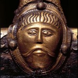
Celtic Europe
26 Sep 2024 19:16
Eastern Montefortino style helmet. From a private collection and allegedly found somewhere in Ukraine. 🇺🇦 This style of helmet was a typical item in the panoplies of Gallic soldiers and mercenaries who were active in Eastern Europe and the Balkans during the 3rd and 2nd centuries B.C.
Celtic Europe - channel link (please share!): /channel/CelticEurope
Читать полностью…
Celtic Europe
24 Sep 2024 19:14
Edward Bruce arrives in Ireland; 26 May, 1315. Art by Seán Ó’Brógáin. 🏴🇮🇪 With Edward are shown Lord Aonghus Óg McDonald of Islay and Sir Fergus of Ardrossan.
In the year following his spectacular victory over England at the Battle of Bannockburn, king Robert I “the Bruce” of Scotland dispatched his brother, the Earl of Carrick, Edward, to Ireland with a large army. Edward landed near Larne in Ulster with a Gaelic army drawn mostly from Argyll and the Hebrides. He’d received a request for aid from the Irish king of Tyrone, Domnall, son of Brian O’Neill. He was met at Carrickfergus by O’Neill and several other Irish chiefs, who pledged fealty to him and proclaimed him High King of Ireland. Edward would be the last person in history to hold this title.
Joined by O’Neill and other north Irish chiefs, Bruce launched a devastating war against the English colonial government. He was even joined by king Robert himself during a brief part of the campaign. The Lordship of Ireland and various Anglo-Norman barons assembled huge armies of English soldiers and Irish vassals to oppose him. Bruce won spectacular victories over them, often against vastly superior numbers. England suffered several notable humiliating defeats, such the Battle of Connor (Sept. 1315), the Battle of Kells (Nov. 1315), the Battle of Skerries (January 1316), and others. The Scottish army also destroyed English towns and castles like Carrickfergus, Dundalk, Ardee, among others, even briefly besieging the colonial capital of Dublin.
Unfortunately, Edward’s army ran out of supplies and dwindled due to battle casualties, plague, and desertion by many of his Irish allies. Ireland was being plagued by famine and pestilence at the time and this hampered the war effort. His Irish allies also blundered into a trap, suffering a devastating mass-casualty defeat at the hands of England at the Second Battle of Athenry (Aug. 1316), where king Felim O’Connor of Connacht was killed; it was the worst military defeat ever suffered by the Irish. Edward’s much diminished (~2,000 men) army was finally defeated by a much larger English and Irish force at the Battle of Faughart (Oct. 1318), where he himself was killed, bringing a tragic end to the Scottish attempt to liberate their Irish brethren.
Celtic Europe - channel link (please share!): /channel/CelticEurope
Читать полностью…
Celtic Europe
21 Sep 2024 17:21
Galatian mercenary; 2nd century B.C. 3D art by Michael Weinert.
Celtic Europe - channel link (please share!): /channel/CelticEurope
Читать полностью…
Celtic Europe
19 Sep 2024 17:35
Relaxing in the heather. 🏴
Celtic Europe - channel link (please share!): /channel/CelticEurope
Читать полностью…
Celtic Europe
14 Sep 2024 18:11
Artistic reconstruction of the hill-fort on Yeavering Bell, in the Cheviot Hills of Northumberland, England. 🏴🏴
Yeavering Bell was the capital of the Brythonic Kingdom of Bryneich, and was formerly known as Din Gefrin. The stone walls enclosed an area of 4.9 hectares and the dry-stone huts would have initially displayed a bright pink hue, as they were made from local andesite, which eventually turns grey with exposure.
Bryneich seems to have been formed in the early medieval period (5th century), being carved from the larger territory of the Votadini tribe. A northern division retained the original name (Votadini is a Latin rendition of the Brythonic Gododdin) with its capital at Din Eidyn (now Edinburgh, Scotland).
This new kingdom of Bryneich was ruled by a dynasty descended from the famed king of York, Coel Hen. It produced notable figures such as king Dyfnwal Moelmut, the renown lawgiver of Welsh tradition, and the infamous Morcant Bulc, who destroyed the Brythonic north by betraying and murdering his relative, king Urien of Rheged. Thanks to Morcant’s actions, Bryneich was somehow taken over by the Angles who’d settled at Din Guardi (Bamburgh). Perhaps wanting to be closer and more relatable to the majority Celtic population of Bernicia, the Anglian kings built a new court not far from Yeavering Bell, which they called Ad Gefrin (today known simply as Yeavering). The Kingdom of Northumbria thus came to have two (probably seasonal) capitals: Bamburgh and Yeavering.
Celtic Europe - channel link (please share!): /channel/CelticEurope
Читать полностью…
Celtic Europe
12 Sep 2024 18:12
Hills and bogland on the isle of Hoy; in Orkney, Scotland. 🏴
Celtic Europe - channel link (please share!): /channel/CelticEurope
Читать полностью…
Celtic Europe
15 Oct 2024 17:17
Autumn in the Chartreuse Mountains of France. 🇫🇷🍂🍁
These mountains are part of the French Prealps and are believed to have taken their name from the town of Saint-Pierre-de-Chartreuse, which may have formerly been called Caturissium. The name Caturissium is in turn believed to derive from an Alpine Gallic tribe, the Caturiges. The Caturiges, or their principal deity Caturix (Gaulish: “Battle King”), also gave its name to the town of Chorges, formerly Caturigomagus (Gaulish: “Plain of Caturix/the Caturiges”).
Celtic Europe - channel link (please share!): /channel/CelticEurope
Читать полностью…
Celtic Europe
14 Oct 2024 16:58
Unfortunately, historical revisionism in the post-modern liberal west has now targeted Europe’s Celtic past. The UK government in Wales is now accusing the legendary king Arthur of having been a transvestite or transgender person (source linked below). 🇬🇧🏴🤡
The Welsh county government in Denbighshire cites a silly folk-tale, first recorded by the Welsh chronicler Elis Gruffydd in the 16th century Chronicle of the Six Ages of the World. The folk story had likely come about as a local attempt to explain the name of a rock near Rhuthun in north Wales. Supposedly, Arthur had disguised himself as a woman to sneak into the area and have an affair with a young woman. He was outed by a former rival, Hueil mab Caw, who recognized his limp. For that, Arthur had Hueil executed on the stone nearby, and from thence the stone got it’s name: Maen Huail (Welsh: “Stone of Hueil”).
Note that this is why historians have been keen to develop the craft of Historiography. Essentially, not every historical document is something that should be taken at face value and sources should always be carefully scrutinized in order to get as close as possible to the truth.
The true story of Hueil mab Caw can be reconstructed from much older sources, sources that were closer to the actual events and not obviously intended as comedy like the folk tale of Maen Huail. Four centuries before Elis Gruffydd, the Welsh monk Caradoc of Llancarfan recorded Hueil’s story in his Life of Gildas: Hueil was a prince of the Brythonic Kingdom of Strathclyde —located in Scotland— where his father, Caw Prydyn, had briefly been king in the late 5th century. He was a mortal enemy of Arthur who frequently brought fleets from Scotland to raid and plunder Arthur’s territory in the Kingdom of Dumnonia, located in England’s West Country. One day, Arthur gathered his own fleet in Cornwall and went in pursuit. He caught Hueil and his men off guard as they’d stopped to rest on the Isle of Man, killing them in battle. Caradoc’s contemporary, Giraldus Cambrensis, confirmed the veracity of this tradition, reporting that Hueil’s brother, the monk Gildas, greatly resented Arthur for this, and in a rage, he destroyed several manuscripts containing records of Arthur’s deeds and praise poems dedicated to him.
It should be obvious even to the simplest of minds that this older story is a more reliable account and that the later tale about Maen Huail was intended as entertainment by bored locals in Denbighshire, whose lives were removed from the time of Arthur by as much as a millenium. But in the post WWII age of destroying and defiling anything and everything related to Europe’s past and culture, this is just the type of psychological warfare people are going to have to endure. Fortunately, European peoples have also inherited an invaluable blessing from some of the Greco-Roman forebears of Western Civilisation: Stoicism. It may just prove to be the most indispensable skill for anyone to cultivate in this day and age.
https://www.msn.com/en-us/news/world/king-arthur-may-have-been-lgbtq-welsh-council-suggests/ar-AA1s6Qls
Читать полностью…
Celtic Europe
12 Oct 2024 16:45
Gallowglass mercenaries in Ireland; 15th century. Art by Graham Turner. 🇮🇪🏴
Celtic Europe - channel link (please share!): /channel/CelticEurope
Читать полностью…
Celtic Europe
09 Oct 2024 17:16
The souterrain of Raitt’s Cave, in Badenoch, Scotland; 100-400 AD. 🏴 Digital Reconstruction by Bob Marshall + 2 photographs.
Souterrains (French: Sous Terrain; “underground”) were common features in Celtic homesteads during the late iron age and early medieval period. They are found primarily in northwest France (Brittany & Normandy) and the British Isles (mainly Scotland, Cornwall and Ireland). In Cornwall they are commonly referred to as fogous; from a word meaning ‘cave’. The concept seems to have originated in northwest France around 500 B.C; and to have proliferated through Britain shortly afterward. Irish souterrains tend to yield later radiocarbon dates, so the concept seems to have reached Ireland last.
People would dig trenches under or adjacent to their homes, then wall them up with drystone and roof them with huge slabs. Once the tunnel was built, they’d cover it over with earth rendering it either wholly or partially concealed. The cool souterrains mainly served as larders for the storage and preservation of foods, including meats. They would have been the closest thing to a refrigerator these people would have had.
Celtic Europe - channel link (please share!): /channel/CelticEurope
Читать полностью…
Celtic Europe
05 Oct 2024 18:41
Silver coin of Duke Conan III “the fat” of Brittany; early 12th century. 🇫🇷
Celtic Europe - channel link (please share!): /channel/CelticEurope
Читать полностью…
Celtic Europe
04 Oct 2024 18:42
Cantabrian Capercaillie (Tetrao Urogallus Cantabricus) in León province, Spain. 🇪🇸
A subspecies of the Western Capercaillie or “wood grouse”, the Cantabrian Capercaillie makes its home in the beech and pine forests of northern Spain. Unfortunately, the destruction of most of the ancient pine woods of the Cantabrian Mountains in modern times has led to a severe decline in the birds’ population. They were once abundant in an area stretching from Galicia to Burgos and La Rioja provinces. Now, their habitat is fragmented, with the largest and healthiest population being located in the northernmost part of the province of León. There are still some relict pine woods there, including a large area of Scots pine forest known as Pinar de Lillo (last two images), where the birds are particularly abundant.
Capercaillies and the pine forests they prefer are abundant in various parts of Europe and Siberia. However, they’ve become emblematic of Scotland. The name of the bird is even derived from the Gaelic capall coille (“Forest horse”), while the predominant tree of its preferred habitat (Pinus Sylvestris) is commonly referred to as “Scots pine” in English, due to its association with the idyllic Caledonian forests of the Scottish Highlands.
Celtic Europe - channel link (please share!): /channel/CelticEurope
Читать полностью…
Celtic Europe
03 Oct 2024 18:06
Marble portrait of a Gaul, found at an uncertain location in Egypt; 1st century B.C. 🇪🇬 Displayed at The Egyptian Museum in Cairo.
Celtic Europe - channel link (please share!): /channel/CelticEurope
Читать полностью…
Celtic Europe
01 Oct 2024 18:10
Reconstruction of female attire based on finds of textiles from a Celtic grave in Nové Zámky, Slovakia; 3rd century B.C. Photo by D. Martinová; model: N. Minárová. Archaeological Museum of Liptov; Ružomberok, Slovakia. 🇸🇰
The outer plaid garment is thought —based on finds of fibulae— to have been identical to the typical Greek garment known as a peplos. These materials were recovered from graves determined to be of Gallic settlers due to their La Tène style grave goods and inhumation burials, both of which were foreign cultural traits introduced to the region after ~400 B.C. Alongside these inhumation graves were found many cremation burials from the same period, as well as the characteristic pit-houses associated with settlements of the Slavic and Dacian peoples who’d always inhabited this part of Europe. Nové Zámky is therefore one of many archaeological sites in Slovakia that’s interpreted as a mixed Celto-Slavic or Celto-Dacian community. Writing in the 1st century AD, the Roman historian Tacitus noted that the inhabitants of the region —whom he called Cotini— spoke the Gaulish language.
Celtic Europe - channel link (please share!): /channel/CelticEurope
Читать полностью…
Celtic Europe
28 Sep 2024 16:51
Downy birch trees (Betula Pubescens) growing in bogland; Wester Ross, Scotland. 🏴
Celtic Europe - channel link (please share!): /channel/CelticEurope
Читать полностью…
Celtic Europe
26 Sep 2024 19:07
Iron sword in bronze scabbard, found in the river Thames near little Wittenham in Oxfordshire, England. 🏴 Detail of the La Tène style decoration of the scabbard shown in the second image. The weapon is believed to date to the 1st century B.C. On display at the Ashmolean Museum in Oxford, England.
Celtic Europe - channel link (please share!): /channel/CelticEurope
Читать полностью…
Celtic Europe
21 Sep 2024 18:10
Scottish mercenaries depicted on the tomb of the Irish king of Connacht, Felim O’Connor (Irish: Feidhlimidh Ua Conchobair) at the Priory of St. Mary in Roscommon, Ireland; AD 1265. 🇮🇪🏴
In the year 1259, Felim’s son and heir, Áed “na nGall” (“Áed of the foreigners”) had married a daughter of the Scottish chieftain Dubhghall mac Ruaidhrí, receiving as a dowry 160 armored Gallowglass warriors to form part of his personal guard. The previous year, that same Dubhghall had raided Connemara in Ireland and robbed an English merchant ship. The Scottish fleet was pursued by that of the English sheriff of Connacht, Jordan d’Exeter, and overtaken at an island where they’d stopped to rest. In the ensuing fight, the Scots massacred the English, including the sheriff himself, then returned to Argyll laden with spoils.
It’s likely that the soldiers given by Dubhghall to Áed also participated with him in several notable battles of the time: The Battle of Downpatrick in the year 1260, a devastating defeat for the Irish at the hands of the English Lordship of Ireland that resulted in the death of one of the last titular High Kings of Ireland, Brian O’Neill, and the Battle of Áth an Chip ten years later, in which Áed and the Irish of Connacht inflicted a stinging defeat on the Lordship of Ireland and the Anglo-Irish De Burgh clan.
Celtic Europe - channel link (please share!): /channel/CelticEurope
Читать полностью…
Celtic Europe
19 Sep 2024 17:49
Map of Celtic Europe by Mikael Bodlore-Penlaez; Geobreizh. 🇫🇷
Map Code:
Grey: Maximum expansion of Celtic peoples in Europe.
Green: Presence of Celtic-speaking peoples in Iberia before the Hallstatt Era (Late Bronze Age/Early Iron Age).
Blue: Probable area of Celtic language expansion before 6th century B.C.
Yellow-striped patches: Origin of La Tène culture.
Yellow line: Extent of La Tène acculturation before 300 B.C.
Grey arrows: Celtic incursions.
Celtic Europe - channel link (please share!): /channel/CelticEurope
Читать полностью…
Celtic Europe
16 Sep 2024 18:20
The burial mound and causeway ditches of Glauberg, in the Wetterau plain of Hesse, Germany. 🇩🇪
The modern rectangular building visible in photos 2 & 3 is an archaeological museum called Keltenwelt (i.e. “Celtic world” or “World of the Celts”) and the forested hill adjacent to it, known as “Glauberg”, contains the ruins of a large hill-fort. This hill-fort seems to have hosted the royal court of a powerful Gallic dynasty from the 5th to 2nd centuries B.C. The mound contained two royal burials; one a cremation, the other an inhumation with rich grave goods. The causeway was aligned to the moonrise point of lunar standstill events which occur every 18.6 years. It appears that the entire site was used for astronomical observations, possibly also for ritual inaugurations, being similar in nature and function to other sites known from the Celtic world such as the Hill of Tara in Ireland and Scone in Scotland. Based on the widespread origin of the Glauberg ruler’s grave goods, it’s been suggested that the kings here held sway over a vast area of southern Germany during the 5th century B.C; their regional hegemony does not seem to have lasted very long. Their kingdom was located at the very edge of the Celtic world, directly neighbouring the territory of the various Germanic tribes. It’s also been speculated that these Celtic people in southern Hesse are the same tribe of people recorded centuries later by the Roman historian Tacitus in the area with the name Mattiaci. It is perhaps a regional name, being the original name of Hesse, as their Germanic neighbours to the north, the Chatti, had a capital named Mattium (near modern Fritzlar).
Celtic Europe - channel link (please share!): /channel/CelticEurope
Читать полностью…
Celtic Europe
12 Sep 2024 20:51
Errigal mountain covered in snow and towering over county Donegal; Ireland. 🇮🇪 Photo by Gareth Wray.
Celtic Europe - channel link (please share!): /channel/CelticEurope
Читать полностью…
Celtic Europe
11 Sep 2024 17:45
Roman troops routed during the Battle of the Allia; 387 B.C. Illustration by Peter Connolly.
Celtic Europe - channel link (please share!): /channel/CelticEurope
Читать полностью…


 3610
3610